

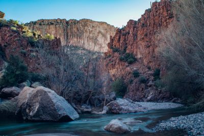
Some of Aravaipa’s cliffs and rock formations stand over 1,000 feet tall, carved by the creek over millions of years. Photo by John Byerly
Enjoying the outdoors is easy to do when you live in the Copper Corridor. There are many places to visit and hike that are in close proximity.
One enjoyable hike is just off Highway 77 on the lower Aravaipa Creek, approximately 10 miles North of Mammoth.
According to BLM, which manages the Aravaipa Canyon area, the access road is usually suitable for passenger cars year round.
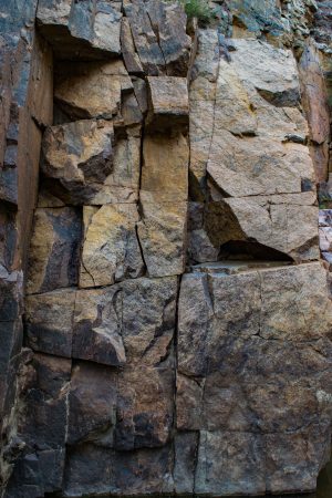
Solid granite-looking stone that has been smoothed by the passing water over the centuries. Photo by John Byerly
From Phoenix (120 miles, 2 to 2.5 hours): Take US Highway 60 to Superior. At Superior, take State Highway 177 to Winkelman. At Winkelman, take State Highway 77, 11 miles to Aravaipa Road (at Central Arizona College). Turn left and go 12 miles to the West trailhead along a paved and graded dirt road. From the trailhead, it is a 1.5-mile hike through Nature Conservancy land to the west wilderness boundary.
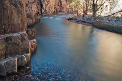
Red rock cliffs contrast beautifully with the turquoise/ aquamarine creek and it’s shimmering light reflections. Photo by John Byerly
From Tucson (70 miles, 1.5 to 2 hours): Take US Highway 77 through Oracle Junction to the Aravaipa Road (8 miles north of Mammoth). Turn right on Aravaipa Road and go 12 miles to the West trailhead along a paved and graded dirt road. From the trailhead, it is a 1.5-mile hike through Nature Conservancy land to the west wilderness boundary.
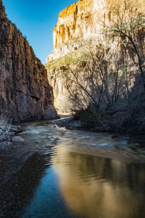
The soft light of the late afternoon sun hitting the cliffs casts the canyon aglow in radiant colors. Photo by John Byerly
Stop and park just in front of the cattle guard about four-tenths of a mile and follow the trail just before the cattle guard. The trail is on the left side of the road along the barb wire fence and is very visible.
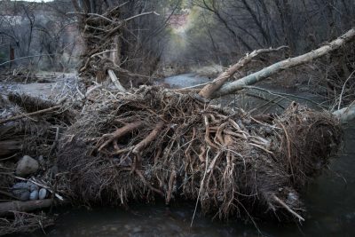
After heavy torrential downpours, Aravaipa is subject to flash floods, ripping trees out by the roots and shooting them downstream . On January 21st of this year, water was measured to be flowing at over 2,000 cubic feet per second. Water levels may have been over 10 feet deep in some parts of the canyon. Photo by John Byerly
This is a relaxing walk that will take you from the cholla cactus to the Aravaipa Creek with tall picturesque trees. Walking in the fall or winter, you will be able to hear the rustling of the leaves as they crunch beneath your feet.
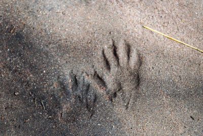
Coati, a member of the raccoon family, footprints in the river bank. The mud banks along the canyon are riddled with footprints from coati, javelina, deer, and bobcats. The canyon is also home to mountain lions, black bears and over 220 species of birds. Photo by John Byerly
The sky above may have a few hawks soaring around along with other colorful birds chirping. It’s a perfect place for a picnic.
A permit is required to visit Aravaipa Canyon Wilderness. The fee is $5 per person per day. Canyon use is limited to 50 people per day, 30 from the West end and 20 from the East end. This system helps to reduce the potential impacts to the environment caused by human use and allows visitors to enjoy the canyon’s solitude.
For more information, please visit the BLM website.
#discovercoppercorridor
There are news or informational items frequently written by staff or submitted to the Copper Basin News, San Manuel Miner, Superior Sun, Pinal Nugget or Oracle Towne Crier for inclusion in our print or digital products. These items are not credited with an author.